Canada Line Construction William Slim |

MapSource is a mapping application sold by the Garmin Corporation. It can contain large maps of North America or Europe showing landmarks such as mountains, rivers, lakes, railways lines, and roads. It features a search function whereby you may search for name, address, city, postal code, country, and by latitude and longitude.

There are some limitations to the Global Positioning System. All civilian GPS receivers are subject to degradation of position and velocity because of Selective Availability (S/A), an operational mode imposed by the American Department of Defense that degrades civilian signals for security purposes. Consequently, the accuracy of civilian GPS receivers may be degraded by up to 100 meters (330 feet). SA was intended to prevent military adversaries from using the highly accurate GPS signals. The government turned off SA in May 2000, which improved the accuracy of civilian GPS receivers. GPS receivers equipped with WAAS (Wide Area Augmentation System) capability can improve accuracy to less than 3 meters on average. Also, because a GPS receiver must track data from at least three satellites at once, it must have a direct line of sight to the sky when used.
To work with MapSource, a GPS receiver must be compliant with NMEA (National Marine Electronics Association) standards, and its input/output format (interface) must be set to support NMEA 0183 version 2.0 or later.
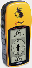
Garman GPS receivers are currently available in Canada for as low as $159. Latitude and longitude coordinates given with each photo were derived from a Garmin receiver. The coordinates are accurate to within 4 meters. Using this software and these coordinates you should be able to easily locate and drive within walking distance of each photo location. If you own a Garmin vehicle navigation system the file is uploadable to your Garmin hardware from the MapSource program.
MapSource maps have a poorer appearance when compared to maps produced by Microsoft Streets & Trips, however they display railway track positions accurately, something Microsoft Streets & Trips does NOT do. While using a Garmin GPS and this software in the United Kingdom the latitude and longitude coordinates obtained from the GPS did not appear in the expected position. There is a positioning error anywhere between 300 to 500 feet. I have not determined the cause of this problem. It is most likely caused by operator error somehow.
For this downloadable file to be useful you will need MapSource installed on your computer. To save the map file to your computer click "Download Now" below then choose "Save this file to disk". You will be asked where you wish to save a file named "garmin.gdb". Choose any suitable folder on your computer.