Canada Line Construction William Slim |
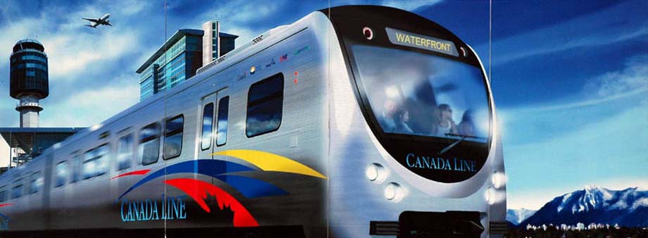

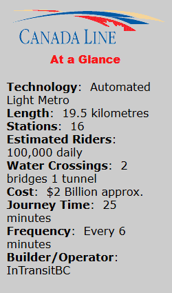
Once complete the Canada Line will connect Waterfront Station on Burrard Inlet with Vancouver's International Airport (YVR) on Sea Island, and Richmond Center in Richmond, a total distance of 19.5 kilometres.
The route involves below ground tunnels, above ground elevated concrete guideways on pillars, plus three water crossings. Construction completion is estimated for 1 Jan 2009 in plenty of time before the start of the 2010 Winter Olympics.
 taken in October 2007 along the route between Waterfront Station and the southern terminus in Richmond.
 Heritage Restaurant & Railway Lounge".
Currently Waterfront Station is the hub for three transportation modes and when the Canada Line is complete it will be the fourth connection. From the station's great hall an entrance leads to the SkyTrain, West Coast Express, and the SeaBus. SkyTrain utilizes Bombardier Advanced Rapid Transit linear induction technology to propel the trains along two routes, the Expo and Millenium lines, through greater Vancouver. (See the map located in the Editorial section.) The Canada Line technology is not as advanced as SkyTrain since it will make use of a typical third rail to power the vehicle's traction motors. West Coast Express trains use Bombardier built coaches pulled by conventional diesel-electric locomotives along trackage owned by Canadian Pacific from the station east to Mission City in weekday only service. The SeaBus is a passenger ferry plying the waters of Burrard Inlet between the station and North Vancouver across the inlet.
 , which pulled the first train to arrive in Vancouver from the east on 23 May 1887. The Roundhouse is located in the area of Vancouver known as Yaletown, hence the dual name for this Canada Line station.
The photos of Langara Station show a good example of the "during and after" condition of Cambie Street. Prior to construction the street was four lanes with a grassed and treed boulevard between. After cut-and-cover tunnel construction the street will be returned to very near its original look except for the addition of Canada Line stations along the route.
 . This type of bridge consists of one or more columns (normally referred to as towers or pylons), with cables supporting the weight of the bridge deck and the load the bridge is required to handle.
Taking the southerly leg from the elevated junction leads to Aberdeen, Landsdowne, and the southernmost terminus of Brighouse at Richmond City centre.
The vehicles for the Canada Line trains are designed and built by the Rotem Company, a division of Hyundai Motor Group, in Changwon City, South Korea. Their transit vehicles utilize conventional traction motors powered by a covered third rail paralleling the standard running rails. This third rail is comprised of aluminum with a steel cap on the rail top to absorb the wear and tear of truck mounted contact shoes.
Rotem Transit Vehicle Features
Driverless operation;
Stainless steel exteriors;
Vandal-resistant finishing;
Gangway connection between each pair of cars;
Wheelchair, stroller, and bicycle accessible;
Wide aisles;
Air conditioning;
Emergency passenger intercom panels;
Emergency silent passenger alarm;
Electronic interior next station signs;
Electronic exterior destination signs;
Public address system.
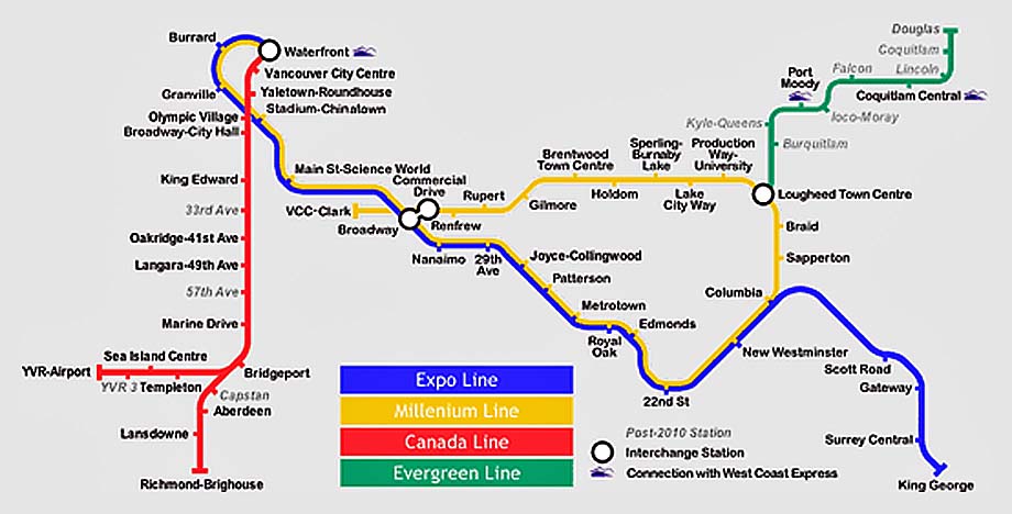
There are four rail transit lines shown on the map of Vancouver above, five if the West Coast Express route were added. Presently the Expo Line and the Millenium lines operate Bombardier's driverless proprietary Advanced Rapid Transit linear induction technology to propel trains. The Canada Line will NOT use Bombardier technology but the more common third-rail and electric traction motor propulsion. The Evergreen Line is expected to be constructed as a driver-operated Light Rail Transit line to some other different technology, perhaps using overhead catenary. Not shown on the map, is the West Coast Express using conventional diesel-electric locomotives for propulsion between Waterfront Station and Mission City, 68 kilometres to the east.

These four different rail technologies require four different types of rolling stock, propulsion, signalling systems, maintenance centres, and skill sets to operate and maintain. All to service what is really one overall rail transit system covering Greater Vancouver.
If Bombardier SkyTrain technology met expectations well enough on the Expo Line to permit the construction of a second line, the Millenium Line, why wasn't Bombardier technology chosen for the third line, the Canada Line? Are we penny wise and pound foolish? Will it cost much more in the long-term because of this choice? Why have we created four different rail transit technologies where there should be only one?
20 Feb 2006 - Alcatel Awarded Euro 25 Million Contract for Driverless Train Control System in Vancouver
2 Aug 2006 - Canada Line Construction
20 Oct 2006 - Richmond Casino is a Crime Magnet
20 Oct 2006 - Evergreen Line Too Expensive?
7 Apr 2007 - Canada Line Reaches Landmark Breakthrough
22 May 2007 - Minister's Asia Tour 2007
31 May 2007 - Schwarzenegger Comes to Vancouver
17 Jul 2007 - Canada Line Going Deep Beneath the Surface
29 Aug 2007 - Tunnel Boring Crew Prepares to Arrive at Yaletown-Roundhouse Station
11 Sep 2007 - Canada Line Tunnelling Firm Denies Union's Pay Allegations
25 Sep 2007 - Error Delays Canada Line Construction
Rotem Vehicle Test Run South Korea (Windows .wmv file)
 sold by the Garmin Corporation. This article provides a downloadable file so you may locate photographs by their latitude and longitude co-ordinates with mapping software on your computer. You require the MapSource program installed on your computer for this file to be useable. If you own a Garmin vehicle GPS navigation system this file may be uploaded from MapSource directly into your vehicle GPS.
Rotem
Bombardier
SNC-Lavalin
Evergreen Line
Do RAV Right
Downtown Historic Railway
Transit Museum Society - TRAMS
Vancouver International Airport
Click/Tap the above image for instructions to save a 2560 x 1440 pixel size image.
