Fraser, Thompson, and Kicking Horse Canyons
British Columbia Canada
N49.562222 W121.431224 (Yale at the start of the Fraser Canyon)


 The province of British Columbia
lying on the west coast of Canada is divided by chains of mountains generally running in a north/south manner. The Canadian Pacific Railway building
westward from eastern Canada in the 1880s, to reach the coast, had to build either over, through, or around this "sea of mountains". For the
most part laying track following a water course provided the best available choice. So... with more than a few hills between, from the Kicking Horse
River in the Rocky Mountains westerly towards the North Thompson, Thompson, and Fraser Rivers, their canyons offered the most plausible route to
tidewater. In this article we will follow through those canyons photographically from Vancouver to Field. Numerous photos collected over several years
of travel have been assembled to show some, just some, of the many sights that may be found along the railway's mainline through the
canyons.
The province of British Columbia
lying on the west coast of Canada is divided by chains of mountains generally running in a north/south manner. The Canadian Pacific Railway building
westward from eastern Canada in the 1880s, to reach the coast, had to build either over, through, or around this "sea of mountains". For the
most part laying track following a water course provided the best available choice. So... with more than a few hills between, from the Kicking Horse
River in the Rocky Mountains westerly towards the North Thompson, Thompson, and Fraser Rivers, their canyons offered the most plausible route to
tidewater. In this article we will follow through those canyons photographically from Vancouver to Field. Numerous photos collected over several years
of travel have been assembled to show some, just some, of the many sights that may be found along the railway's mainline through the
canyons.
 The Canadian Pacific Railway Limited (CP), a private company, was incorporated on 16 Feb 1881
to construct a standard gauge railway from Montreal to Port Moody on the west coast. The 1881 construction season was abysmal. By the end of the season
only 131 miles of track had been completed. However, CP did grow considerably in size that year due to the amalgamation with the 254 mile Canada Central
Railway which gained it access to Ottawa. Enter William Cornelius Van Horne, their newly hired General Manager, who boasted he would build 500 miles of
mainline railway in his first year, 1882. Floods delayed the start of the construction season but by season's end 418 miles of mainline and 110 miles of
branchline track laying made CP more of a reality. Meanwhile, CP obtained permission to change the prescribed Yellowhead Pass route to a southerly route
through British Columbia's mountain chains. In 1882 the now famous Rogers Pass was discovered by the American Major "Hells Bells" Rogers.
The Canadian Pacific Railway Limited (CP), a private company, was incorporated on 16 Feb 1881
to construct a standard gauge railway from Montreal to Port Moody on the west coast. The 1881 construction season was abysmal. By the end of the season
only 131 miles of track had been completed. However, CP did grow considerably in size that year due to the amalgamation with the 254 mile Canada Central
Railway which gained it access to Ottawa. Enter William Cornelius Van Horne, their newly hired General Manager, who boasted he would build 500 miles of
mainline railway in his first year, 1882. Floods delayed the start of the construction season but by season's end 418 miles of mainline and 110 miles of
branchline track laying made CP more of a reality. Meanwhile, CP obtained permission to change the prescribed Yellowhead Pass route to a southerly route
through British Columbia's mountain chains. In 1882 the now famous Rogers Pass was discovered by the American Major "Hells Bells" Rogers.

By 1883 track had crossed the northern portion of the Blackfoot reserve at Gleichen headed for the mountains. But by the beginning of 1885 the
railway teetered on the brink of bankruptcy. The north shore of Lake Superior, the Rockies, and the Selkirks were the most difficult and expensive
sections to build. Some small sections cost nearly half a million dollars per mile and it almost ruined the railway. With bankruptcy hanging over the
railway Louis Riel chose that particular moment in time to return from exile in America to stage his second insurrection. Canadian troops carried on the
incomplete railway from the east to quell this rebellion took just several weeks to arrive, whereas the first insurrection of 1869 had taken several
months to reach the unrest by travelling through American territory. Due to the significance of this event the federal government agreed to secure CP's
outstanding loans thereby staving off bankruptcy. 7 Nov 1885, at Craigellachie, in the British Columbia mountains, Donald Smith, a senior director of
the company, drove the Last Spike to complete the railway between Port Moody and Montreal.
 Between Vancouver on the west coast, and Field
in the Rocky Mountains, Canadian Pacific's mainline is divided into four subdivisions about 130 miles each in length, Cascade, Thompson, Shuswap, and
Mountain Subs. (Yes, Canada is metric, but the railways must have been granted an exemption as they still use miles to measure their routes.)
Between Vancouver on the west coast, and Field
in the Rocky Mountains, Canadian Pacific's mainline is divided into four subdivisions about 130 miles each in length, Cascade, Thompson, Shuswap, and
Mountain Subs. (Yes, Canada is metric, but the railways must have been granted an exemption as they still use miles to measure their routes.)
Note that when referencing a direction the railway designates the mainline route as either east or west regardless of the actual physical direction in which the track lies, north south in many cases, or any other direction for that matter. Sidings are designated as the north or south track depending on which side of the mainline they lie.
Cascade Subdivision - Across Canada Canadian Pacific Railway mileposts are recorded on each subdivision from east to west. For example, the Cascade Sub starting point is milepost 0.0 located at North Bend while Vancouver lies at milepost 129.1 to the west. (The photos with this article are arranged in the opposite direction so below we'll name the stations in reverse order to the timetables.) Departing Vancouver Cascade Sub tracks run east to Second Narrows, Port Moody, Port Coquitlam, Haney, Mission, Agassiz (pronounced AG-a-seas), Haig, Yale, and North Bend to name a few.
Thompson Subdivision - Stations are North Bend (opposite Boston Bar) to Cisco (pronounced SIS-coh), Lytton, Spences Bridge, Nepa (pronounced NEE-pah), Ashcroft, Savona, and Kamloops.
Shuswap Subdivision - Kamloops to Chase, Notch Hill, Shuswap, Sicamous, Craigellachie (pronounced cray-GAL-a-key), and Revelstoke.
Mountain Subdivision - Revelstoke, Glacier, Stoney Creek, Golden, Glenogle, Ottertail, and finally Field. For the railway, Field marks the time zone change between Pacific Time, in the west, and Mountain Time in the east. Just to confuse you further, Pacific Time is used on the Mountain Sub, west of Field, and Mountain Time is used on the Laggan Sub, east of Field, while the townsfolk seem to use Pacific Time, which changes to Mountain Time on the other side of the mountain. So, if you can't tell what time it is, you're normal.
The Mountain Sub encompasses some pretty spectacular railway engineering. This includes the famous Rogers Pass tunnels, Connaught, the short Shaughnessy tunnel, and the Macdonald with their associated viaduct, (See this diagram) and don't forget Stoney Creek, Mountain Creek, and Surprise Creek bridges. Just west of Golden lies KC Junction, the connection to the Windermere Sub which runs south to British Columbia's coal mines and the source of all those coal carrying unit trains visible all the way to Pacific tidewater.
Co-production Trackage - We will ignore trackage in the Vancouver area which is reasonably too complex for this article but must mention the "co-production" trackage on the Cascade and Thompson Subs. First, lets backtrack on a little history. CP, as the first railway to be built across Canada, had first choice of the route through the Fraser and Thompson Canyons. Later, Canadian National Railway (CN) ended up operating a second line constructed through those same canyons, usually on the opposite side, making more difficult to build. Since CN's inception the two railways have been competitors but in 1999 they joined forces to share their trackage for directional running through the canyons between Mission and Nepa.
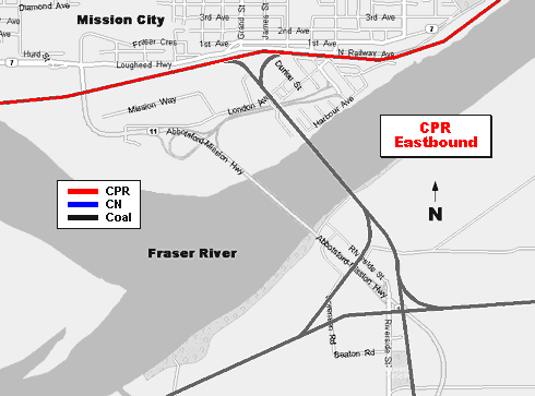
The heaviest tonnage through the canyons is generally westbound so the CN line with its flatter grade sees both CN and CP trains westbound beginning at Nepa located just south of Ashcroft. The trains after exiting the Fraser Canyon then separate at Mission, returning to their respective trackage. Eastbound CN trains leave CN trackage at Matsqui Junction for Mission where they join CP trackage for the eastward trip to Nepa. They rejoin CN trackage upon reaching Nepa. This arrangement is now the general operating practice but there are exceptions to this procedure. A derailment, for example, would divert traffic to the opposite railway. Another example... when CP was operating their Hudson steam locomotive number 2816 it wasn't permitted on CN trackage so it ran westbound against the normal flow of traffic on CP's co-production trackage.
Here are the four subdivision timetables showing all the stations and mileages:


 Canadian Pacific, Canadian National, Rocky Mountaineer, and VIA Rail trains travel through the
Fraser and Thompson Canyons on co-production trackage. Commencing with a light rainfall in the lush green forests of Yale and Spuzzum the video moves
eastwards towards the semi-arid desert country at Cisco, Martel, the Black Canyon, and Walhachin (pronounced wall-a-SHEEN), then jumps back west to
Spences Bridge, and then even further west by returning to Yale.
Canadian Pacific, Canadian National, Rocky Mountaineer, and VIA Rail trains travel through the
Fraser and Thompson Canyons on co-production trackage. Commencing with a light rainfall in the lush green forests of Yale and Spuzzum the video moves
eastwards towards the semi-arid desert country at Cisco, Martel, the Black Canyon, and Walhachin (pronounced wall-a-SHEEN), then jumps back west to
Spences Bridge, and then even further west by returning to Yale.
18 May 1882 - Railway Construction
26 Jan 1983 - Vic Runs "Cadillac" Trains on the Coal Run
16 Nov 1983 - Main Line Tunnels Slated for Major Clearance Work
7 Jan 2005 - Rogers Pass CPR Mountain Sub for MSTS
2 Apr 2007 - Cisco Before and After
5 Sep 2007 - Canadian Pacific FP9A in the Canyons
10 Oct 2007 - Traffic Moving Again on CP Rail Line in B.C. After Derailment
22 May 2008 - A Group Photo Story
2 Jul 2008 - Divers Inspect Chemical Loaded Train Cars in Thompson River
25 Sep 2008 - Canadian Pacific Spirit Train Photo
30 Jun 2009 - CP Rail History Exhibited in Calgary
21 May 2016 - CP Installs Locked Gate at Kicking Horse River in Golden
24 Jun 2016 - Golden Rafting Companies Use Helicopter to Circumvent CP Gate
26 Oct 2016 - CN Working to Reopen Tracks Near Yale
24 Nov 2017 - Train Derails Near Hells Gate
Rocky Mountaineer (Link fails 24 Mar 2022)
Wikipedia - Canadian Pacific Railway
Revelstoke Railway Museum (server returns an invalid response)
 By Train Through the Canadian Rockies
Canadian Pacific Limited
Date unknown
Canadian Pacific Limited 500-Gulf Canada Square 401-9th Avenue SW Calgary AB T2P 4Z4.
Booklet.
7.75 x 9.75 inches 19.5 x 24.5 centimetres 24 pages $15.00
Travel booklet held by University of BC Special Collections Division shelved at spam 2053.
By Train Through the Canadian Rockies
Canadian Pacific Limited
Date unknown
Canadian Pacific Limited 500-Gulf Canada Square 401-9th Avenue SW Calgary AB T2P 4Z4.
Booklet.
7.75 x 9.75 inches 19.5 x 24.5 centimetres 24 pages $15.00
Travel booklet held by University of BC Special Collections Division shelved at spam 2053.
 Canadian Pacific in the Selkirks Volume 1
Booth, Jan
1985
British Railway Modellers of North America 5124-33rd St. Northwest Calgary AB T2L 1V4.
Stapled.
11 x 8.5 inches 28 x 21.5 centimetres 49 pages $10.00
Large photographs and colourful captions help to give a fascinating glimpse into railway operations over the past century in the mountain area.
Canadian Pacific in the Selkirks Volume 1
Booth, Jan
1985
British Railway Modellers of North America 5124-33rd St. Northwest Calgary AB T2L 1V4.
Stapled.
11 x 8.5 inches 28 x 21.5 centimetres 49 pages $10.00
Large photographs and colourful captions help to give a fascinating glimpse into railway operations over the past century in the mountain area.
 Railway Mileposts British Columbia Volume 1
Burrows, Roger G.
1981
Railway Milepost Books Box 593 Sta. A North Vancouver BC V6C 2N3.
Perfect bound.
8.5 x 11 inches 21 x 27.5 centimetres 112 pages $9.95
Maps and information on points of interest to railfans and photographers.
Railway Mileposts British Columbia Volume 1
Burrows, Roger G.
1981
Railway Milepost Books Box 593 Sta. A North Vancouver BC V6C 2N3.
Perfect bound.
8.5 x 11 inches 21 x 27.5 centimetres 112 pages $9.95
Maps and information on points of interest to railfans and photographers.
 Glacier House Rediscovered
Finch, David
1991
Friends of Mount Revelstoke & Glacier.
Soft cover.
11 x 8.5 inches 28 x 21.5 centimetres 46 pages $9.58
Photos and brief story about CPR's Glacier House Hotel near Illecillewaet Glacier in the Selkirk Mountains.
Glacier House Rediscovered
Finch, David
1991
Friends of Mount Revelstoke & Glacier.
Soft cover.
11 x 8.5 inches 28 x 21.5 centimetres 46 pages $9.58
Photos and brief story about CPR's Glacier House Hotel near Illecillewaet Glacier in the Selkirk Mountains.
 Canadian Pacific in the Selkirks Volume 2
Steed, Roger G.
1993
British Railway Modellers of North America 5124-33rd St. Northwest Calgary AB T2L 1V4.
Stapled.
11 x 8.5 inches 28 x 21.5 centimetres 35 pages $13.00
Photos with captions of Rogers Pass Project construction, tunnels, and John Fox viaduct.
Canadian Pacific in the Selkirks Volume 2
Steed, Roger G.
1993
British Railway Modellers of North America 5124-33rd St. Northwest Calgary AB T2L 1V4.
Stapled.
11 x 8.5 inches 28 x 21.5 centimetres 35 pages $13.00
Photos with captions of Rogers Pass Project construction, tunnels, and John Fox viaduct.
 Rail Tales From the Revelstoke Division
Nobbs, Ruby
2000
Friesens Corporation - Altona MB R0G 0B0.
Hard cover.
6 x 9 inches 15.5 x 23.5 centimetres 96 pages $14.93
Ruby Nobbs was an archivist at the Revelstoke Museum for many years who collected personal local stories and newspaper articles which are included in
this book.
Rail Tales From the Revelstoke Division
Nobbs, Ruby
2000
Friesens Corporation - Altona MB R0G 0B0.
Hard cover.
6 x 9 inches 15.5 x 23.5 centimetres 96 pages $14.93
Ruby Nobbs was an archivist at the Revelstoke Museum for many years who collected personal local stories and newspaper articles which are included in
this book.
 Canadian Pacific Railway on the Revelstoke Division Volume 1
Mayer, Douglas R.
2018
Revelstoke Heritage Railway Society C/O Revelstoke Railway Museum PO Box 3018 Revelstoke British Columbia Canada V0E 2S0.
Soft cover.
8 1/2 x 11 inches 21.5 x 28 centimetres 28 pages $25.25
Photograph book with black and white images and lengthy informative captions displayed in a format similar to the British Railway Modellers of North
America (BRMNA) group of publications.
Canadian Pacific Railway on the Revelstoke Division Volume 1
Mayer, Douglas R.
2018
Revelstoke Heritage Railway Society C/O Revelstoke Railway Museum PO Box 3018 Revelstoke British Columbia Canada V0E 2S0.
Soft cover.
8 1/2 x 11 inches 21.5 x 28 centimetres 28 pages $25.25
Photograph book with black and white images and lengthy informative captions displayed in a format similar to the British Railway Modellers of North
America (BRMNA) group of publications.
This website displays on 3 size screens but is best viewed at 1920 x 1080 pixels:


Vancouver Island British Columbia Canada © Copyright 2018 William Slim - Data Wrangler.