 |  Article |
FROM LAGGAN TO REVELSTOKE
BRITISH COLUMBIA
3 March 1900
THE construction of the transcontinental line of the Canadian Pacific Railway and the development of the western provinces of the Dominion of Canada, Manitoba, Assiniboia (Saskatchewan), Alberta, and British Columbia, are so intimately connected that the history of the one almost of necessity includes that of the other. The first white men to settle in these regions were the agents of the Hudson's Bay Company, who built their forts along the branches of the Saskatchewan River, and even pushed into the eastern ranges of the Rocky Mountain system. The explorations of Sir Alexander Mackenzie and Sir George Simpson furnished some information as to the condition of the central ranges of the Rocky Mountains, about which practically nothing had been known before except from the vague accounts of Indians and stray hunters.
British Columbia being separated from the provinces to the east by great ranges of mountains, it soon became apparent that the natural barriers would be great obstacles to the development of this vast territory, and as early as 1834 the advantages of a transcontinental line were urged. 1 No active steps were taken, however, until the British Government, realizing the importance of rapid communication between the Atlantic and Pacific in connection with its colonies in India and Australia, organized and sent out in 1857 an expedition under the command of Captain John Palliser. One of the objects of this expedition was to explore "that portion of British North America which lies between the northern branch of the river Saskatchewan and the frontier of the United States, and between the Red River and the Rocky Mountains," and "to ascertain whether one or more practicable passes exist over the Rocky Mountains within British territory, and south of that known to exist between Mount Brown and Mount Hooker." 2.
2. "British Blue-book: Accounts and Papers, Colonies" No. 39, 1863, pages 4 and 5.
This expedition remained in the field from 1857 until 1860, during which period it mapped a large portion of the provinces of Assiniboia, Saskatchewan, and Alberta, besides finding four pass's through the Rocky Mountains. The results were not considered favorable for the construction of a transcontinental line, as Captain Palliser in his report, says, "The knowledge of the country, on the whole, would never lead me to advocate a line of communication from Canada across the continent to the Pacific, exclusively through British territory. The time has now forever gone by for effecting such an object, and the unfortunate choice of an astronomic boundary line has completely isolated the Central American possessions of Great Britain from Canada in the east, and also almost debarred them from any eligible access from the Pacific coast on the west." 3 In the light of what has actually been accomplished, these remarks of Captain Palliser are most interesting, especially as the pass which he considered the least practicable across the main range of the Rocky Mountains was the one adopted in the construction of the Canadian Pacific Railway.
In 1867 the eastern provinces united themselves into the Dominion of Canada, and immediately steps were taken to embrace the great territory lying to the westward. The Hudson's Bay Company claiming control, a payment of $1,500,000, coupled with other privileges, was made for territory as far west as the summit of the Rocky Mountains, and in 1871 British Columbia entered the union on condition that railway communication be given with the more eastern provinces within ten years. Thus the Dominion was extended from the Atlantic to the Pacific, and embraced territory varying from the well settled portions of the east to the wild and practically unexplored plains and mountain ranges of the west.
In this way the construction of the transcontinental line became an active project, and resulted in 1872 in the formation of two companies to undertake the work. These were united soon after, under the presidency of the late Sir Hugh Allen, and a contract was entered into with the Canadian Government by which it was to furnish $30,000,000 in cash and 50,000,000 acres of land in consideration of the company completing the road.
3. "British Blue-book: Accounts and Papers, Colonies" No. 39, 1863, page 16.
Outside financial aid failing, the company was not able to carry out its agreement, and political changes also took place, making it difficult for the Government to fulfil its part. It was accordingly decided in 1874 to carry on the work as a public enterprise, and in 1875 construction was commenced west of Lake Superior and on the Pacific slope of the Rocky Mountains.
 The Onderdonk contracts along the Fraser and Thompson Rivers.
In 1880 the road was far from completion, when another change in the Government brought the original projectors into power again, and it was decided to revert to the first policy of constructing the road as a private enterprise. The Government, however, agreeing to turn over all the work completed or under construction, to furnish $25,000,000 and 25,000,000 acres of selected land in the Fertile Belt, and to give right-of-way through public property, besides other valuable franchises. On the other hand, the Company agreed to construct about 2,000 miles of road, and to complete within a period of ten years the transcontinental line joining the Atlantic and Pacific.
Many difficulties arose on the score of finance and construction, but on November 7, 1885, the last spike was driven at Craigellachie, British Columbia, 2,555 miles west of Montreal. There was thus completed wholly in British territory one of the longest, and in places, most difficult railways ever constructed. North of Lake Superior immense cuttings in solid granite were necessary, while the grades, mud slides, snow, and deep ravines of the Rocky Mountains required the greatest care and skill of the engineer. During the construction of the road $2,100,000 were expended in explosives alone, while a single mile on the north shore of Lake Superior cost the sum of $700,000.
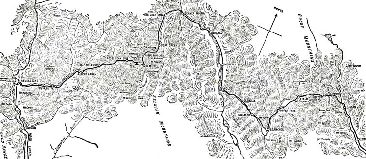
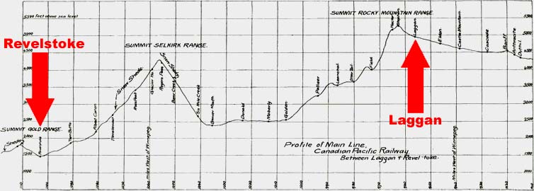
It is to one of the most difficult sections on the road to construct and maintain, lying between Laggan and Revelstoke in British Columbia, and embracing a mileage of but 147 miles, that I wish to draw your attention this evening, and to explain some of the features of operation which must appeal to every traveler over the line. (Figures 1 and 2. Pages 4 and 6.)
The Rocky Mountain system, as it stretches northward, converges and contracts, until in British Columbia it exceeds but little a breadth of 500 miles, being composed of four principal ranges, the Rocky, the Selkirk, the Gold, and the Coast. In the construction of the railway it became necessary to cross all four of these ranges. The canyon of the Fraser River where it crosses the Coast Range being used by the railway, a high pass was not necessary at that point, but the other ranges, being greater in altitude and more continuous, required heavy grades, and passes in valleys several thousand feet above sea level. A number of routes were surveyed, it being desired to keep at least 100 miles from the international boundary and as far south as possible, in order to avoid the severe winters of the far north, and at no place to exceed a grade of one percent.
 As the author is giving this talk to Americans he omits mentioning the Canadian Pacific's southerly route was intended to block American encroachment into "British" North America.
After crossing a wide expanse of prairie the eastern slope of the Rocky Mountain range is ascended without difficulty through the comparatively level valley of the Bow River, almost to its source. The "height of land" is reached in a narrow valley, 5,296 feet above sea level, on each side of which great snow capped mountains stand as sentinels. At no point does the grade exceed one percent, the limit prescribed by the Government in its agreement permitting the construction of the road.
While the actual summit is at Stephen, the nominal one is at Laggan, a divisional point on the railway. Here engines are changed, and the whole train is given a thorough inspection before descending the steep grade of the Kicking Horse Pass. Once over the summit, there is a short space of comparative level, and then the increased grade of 4.4 percent, is reached, down which the train is allowed to move at a very slow rate. Brakemen are stationed at every platform, and it is amusing to see them at times jump from the cars and run alongside to watch the working of the brakes. Engines specially designed for the heavy grades are used between Field and Hector, and it is not at all uncommon for four of these to be required to take the east-bound express to the summit of the pass. This particular part of the road, nine miles in length, was constructed as a "temporary line" of much steeper grade than that allowed by the Government. The contract route lies upon the almost perpendicular sides of Mt. Stephen to the left, and would involve extensive tunneling, as well as passing directly beneath the forefoot of a glacier on this stupendous mountain, from which at times great masses of ice fall to the valley below.
At intervals on the grade are located blind sidings running up the mountain side at a steep grade. The switches of these sidings are tended by watchmen, who, on the signal of the engineer, throw the switches and allow the train to pass, when they are again opened. By this means a runaway train would be diverted from the main track before it had gone a sufficient distance to do serious damage.
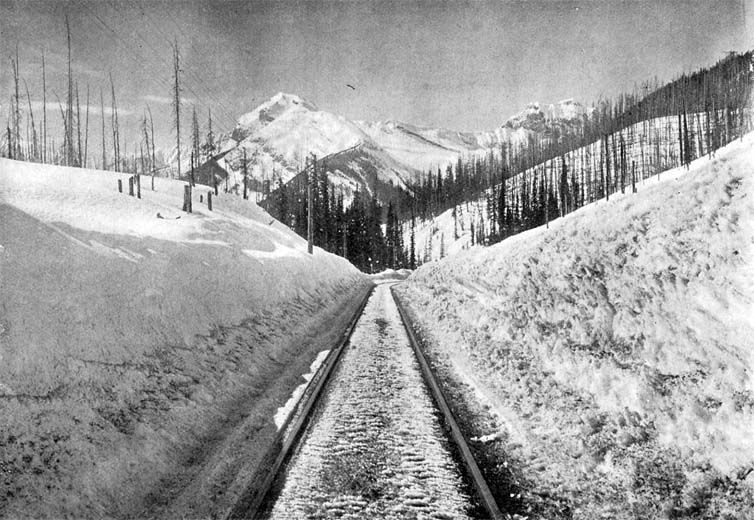
The snowfall in this pass is heavy, but does not give the trouble experienced in the Selkirk range to the west. One reason for this is the absence of snow slides across the track, and while the falls at times are very heavy, they can be readily handled by the plows and scrapers. Some extracts from the record of the watchman at Hector Station may be of interest as giving an idea of the amount of snow expected during the winter months. While snow sometimes falls in every month in the year, 4 the records usually begin about the first of November and end the middle of March, the average for this period for the past five years being 27 feet 4 inches. During the winter of 1897-1898 the snowfall was 41 feet, while in 1898-1899 but 23 feet fell. It is an interesting fact that when the fall in the Rockies is heavy, the fall in the Selkirks is often light, and vice versa. The amount of snow that may fall in a very short time is sometimes almost incredible, and it is not unknown for 100 inches to be recorded in two weeks, while in a single week 57 inches have been observed. (Fig. 3. Page 8) 5
Field, at the foot of the pass, is situated by the side of the Kicking Horse River, which is here a broad, muddy stream occupying but a fraction of its bed. The pass and river, like many other localities of the neighborhood, take their name from a peculiar incident. When Dr. James Hector, a member of the Palliser expedition, traversed the pass in 1858, he was so unfortunate as to be kicked in the chest by his riding horse while trying to catch a pack animal that had escaped. Being partly disabled, the party was obliged to camp for a number of days to await his recovery, and Kicking Horse was adopted as the name of the river and pass where the accident occurred. 6
5. For the foregoing information I am indebted to Mr. H.C. Kelleen, track master, Field, B.C.
6. "British Blue-book: Accounts and Papers, Colonies" No. 39, 1863, pages 105 and 106.
After leaving Field several small ascents are encountered, but the general grade is downward until the lower canon of the Kicking Horse is reached. Hemmed in on both sides by very steep rocky sides, there is often little room left for the railway beside the river, and it is forced to cross and recross on wooden Howe truss bridges, which will soon be supplanted by more substantial steel. Some tunnel work was required on this part of the line. No difficulty has been experienced with that through rock, but morainic material and clay were encountered in several instances, and gave endless trouble, owing to the expansion of the loose masses. In one case the tunnel caved in entirely, and it became necessary to cross the river twice or to construct a curve of exceedingly short radius to pass around it. The latter plan was chosen, and a curve of 23 degrees was constructed. At first, in order to pass this curve, all the cars were uncoupled and fastened together with short chains, but after a slight adjustment this has been rendered unnecessary.
In these narrow canyons, occupied almost entirely by rivers, freshets are of constant occurrence, and often do great damage. Contrary to what we are accustomed to in the East, sudden rises in water are not often the result of heavy rain storms. While, of course, these have some effect, yet the porous character of the soil absorbs a large part of this water. The rapid melting of the snow fields and ice masses caused by a spell of warm, moist weather is almost entirely responsible for these freshets, which, on this account, may occur at any period of the summer months, and may last for days, or perhaps weeks. The melting caused by the heat of an ordinary day is sufficient to change a brooklet to a raging torrent, while the effect on a river of larger proportions is much more marked. These rapid changes in the height of water have required a much more permanent construction of embankments than would otherwise appear necessary, and in this and other canyons the river has been controlled by walls of solid masonry, on which the tracks are laid, thus insuring against accident even during the most severe disturbances.
At Golden the railway suddenly emerges from the narrow canyon of the Lower Kicking Horse into the broad, level valley of the Columbia River. Here the mountain ranges are on either side, the Rockies on the right, and the Selkirks on the left. At this point the course of the Columbia River is a little west of north, until, finding a pass through the Selkirk range, it completely reverses its direction and flows south to the international boundary.
By following the river an easy grade could have been obtained for the railway, but the cost of tunneling and bridging would have been very great. It was, therefore, decided to shorten the distance some eighty miles, or about one-third, by cutting directly across the Selkirk range to the Columbia River beyond. The passes through this range were entirely unknown until the explorations of the engineers in laying out the line of the railway. The Indians, owing to some superstitious belief, would not enter the mountains, and prior to 1883, when Major Albert B. Rogers discovered the pass that now bears his name, the foot of man had seldom crossed their slopes. After following the level valley of the Columbia for a number of miles the railway crosses the river on a fine bridge, and as the valley rapidly narrows, clings to the side far above the water. At Beaver Mouth, which as its name indicates, is situated at the point where the Beaver joins the Columbia, the latter river is left on the right, still flowing in a northerly direction, and the winding course of the Beaver is followed. Extensive sawmills are situated at this point, until recently driven by water-power from a stream on the side of the foothills led down in a flume and carried directly under the railway by a great inverted siphon. Now steam has exerted itself, and the flume, once quite the wonder of the traveler, is rapidly going to decay. After leaving Beaver Mouth the canyon becomes very narrow, and at places the stream is spanned by a single log thrown across from bank to bank.
The difficulties in crossing the Selkirk range lay not so much in the steepness of the grades, which do not exceed 2.2 percent, or in the cost of actual construction, as in the precautions it was necessary to take against the immense snowfall and terrible avalanches. The average yearly snowfall between 1895 and 1898 was 31 feet, while in the winter of 1898-1899 the recorded fall was 43 feet 8 inches. These amounts were obtained after careful measurements on the platform at Glacier House, and there is no doubt as to their accuracy.
The fall from October 1898, to May 1899, in totals for each month, is as follows:
| 1898 October November December 1899 January February March April May Total fall | 0 feet 10 inches 8 " 4 1/2 " 6 " 6 " 9 feet 2 inches 6 " 9 " 6 " 2 " 3 " 7 " 2 " 4 " ————————— 43 feet 8 1/2 inches. |
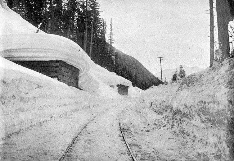
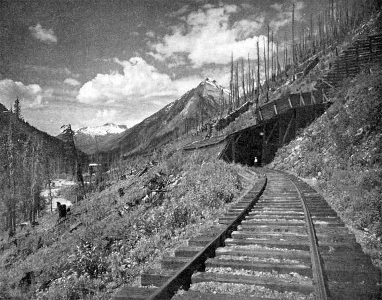
By the aid of rotary snow plows any depth of snow that has fallen directly from the sky and is not intermingled with rocks, mud, and tree trunks may be dug out and thrown to a considerable distance from the track. Points that are not liable to be covered with avalanches are thus left unprotected, and there is seldom serious difficulty in keeping the road open, even during the most severe storms. Where many rocks or trees are mingled with the snow, or where the snow has been compacted to ice, the problem is a much more serious one, and great labour is involved in blasting out the confused mass and clearing it away by hand. (Fig. 4 Page 11.)
The immense banks of snow that are formed on the mountain sides frequently slip from their insecure positions and go thundering to the valley below, carrying with them masses of rocks, trees, and earth. These snow avalanches and those composed of wet mud and stones are most dreaded by the railway company, and it has been in an endeavor to reduce their power of destruction that costly structures in the form of snow sheds and bridges have been erected.
Wood was used almost exclusively in the first construction of the division crossing the mountains. Timber was abundant, and in this way the road was opened for traffic many months before it would otherwise have been possible. No provision was at first made for protection from snow, but during the winter of 1885-1886 a corps of engineers was kept constantly on the ground observing where the worst slides took place, and how structures should be built to withstand them. During the following summer 35 sheds were constructed at the summits of the Selkirk and Gold ranges, but the winter of 1886-1887 being unusually severe, they were increased the next summer to 53, with a total length of over six miles. This mileage has been added to slightly from time to time as occasion arose.
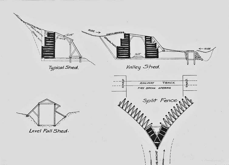
The sheds, as constructed, are of two principal types, according to the severity of the avalanches to be withstood by them and the position in which they occur. To protect the track from the ordinary snowfall only, the "level fall shed", a comparatively light structure, meets all requirements, but on the steep slopes of the mountains immense cribwork and deflectors are necessary. The latter are of two principal types, those that must withstand avalanches from one side only, and those that may be attacked from both. (See Fig. 5, page 13.) An avalanche does not stop at the bottom of the valley, but often sweeps up the opposite side, doing double damage because coming from a direction least expected. The sheds must accordingly in many instances be made of sufficient strength to withstand avalanches from either direction Cases are on record where laborers on the tracks have been killed by not heeding an avalanche on the opposite side of the valley, which they supposed was too far from them to be dangerous.
The avalanche itself is not the only destructive agent in these regions. Currents of air are set up by the swift downward motion of the mass, and often do great damage, as they extend over a wide area and have immense power. They are called "snow flurries", and at times have sufficient power to twist off the trunks of full-grown trees perhaps fifty feet from the ground, leaving only the stumps standing. After the passage of a snow flurry the leaves are burned brown, as though subjected to great heat.
In the construction of the snow sheds the strongest materials were used, and these were found close at hand in the forests. Cedar timbers, mostly 12 inches by 12 inches, formed the cribwork, but Douglas fir (Oregon pine) was employed in members subjected to severe transverse strains. The bents, usually spaced about five feet centers, were built up of 12 inch by 15 inch timbers, securely braced and drift bolted together. Above the shed the ground is cleaned and leveled, with the object of giving the avalanche an upward motion, thus tending to shoot across the track. An idea may be gotten of the immense power of these avalanches from the fact that comparatively new sheds have been entirely demolished during the breaking-up of an unusually severe winter. In order to guard against destruction by fire systematic measures have been adopted. Where it is necessary to protect a long piece of track from avalanches, the sheds are divided into several short sections, with open spaces of about 200 feet between them.
These open spaces are protected by heavy V-shaped fences of cribwork placed above. (See Figs. 5 and 6. Page 13 and 14) An avalanche striking one of these fences is deflected to the right and left upon the sections of the shed, and so passes, without doing harm, to the valley below. The open spaces also allow the sheds to clear of smoke very rapidly, which in winter, when all the small openings are filled with snow, would otherwise require hours. A complete system of sluices and piping leads water from the streams above to the tops of the sheds, and in case of the occurrence of fire, the watchman, who is always on duty, will be able to control it promptly. In many cases a temporary track is laid beside the shed, which is used in summer, thus greatly reducing the fire risk, and allowing the passengers to see to better advantage some of the finest scenery.
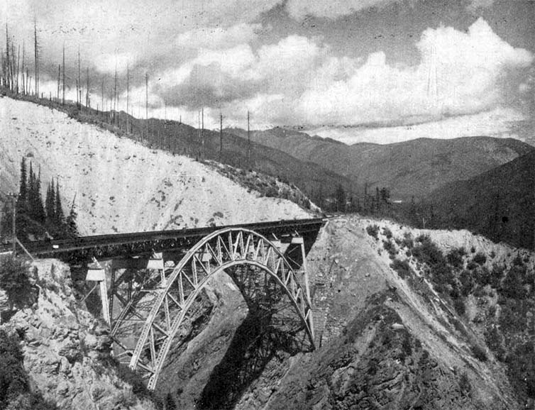
Where avalanches can not be made to pass over the track, bridges are provided, so that they may go beneath them. On the east slope of the Rogers Pass grade several great ravines are crossed, which at first were spanned by wooden trestles, these now being replaced by more permanent structures. The largest of these crosses Stony Creek. It was originally built of continuous Howe trusses, having spans of 33, 161, 172, and 86 feet respectively, and supported on wooden trestle towers 200 feet high, resting on concrete footings. While still in good condition in 1893, it was decided to replace it with steel, a continuous arch of 336 feet span and 300 feet above the chasm being completed just before a destructive forest fire swept over the region. (See Fig. 7. Page 16.) Several other bridges have been reconstructed in a most substantial way, one of the principal factors in the design being to allow the avalanches of mud and snow to pass safely beneath them. In the old wooden bridges, a few examples of which still remain, the flurry caused by the slide passing beneath was withstood by heavy rods of iron anchored to "dead men" on the upper side of the valley. Cribwork to the right and left deflected the slide so that it passed between the supports instead of carrying them with it. But even with the most substantial construction and care in design it has not been possible to save some of the bridges from total destruction. The structure spanning Cascade Creek was swept away six times before it was replaced by a single arch of masonry, which, it is expected, will withstand all attacks. It is an interesting fact that this entire stream emerges from the ground a few hundred feet above the line of the railway.
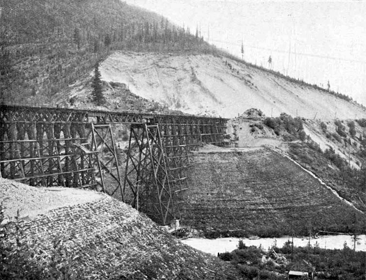
While in many cases it was possible to span the courses of streams by bridges, a number were of such width that long trestle work became necessary. The problem of reconstructing these was a very serious one, owing to the cost of labor and the difficulty of moving material on the steep grades. At certain points, however, it was only possible slowly to fill in an embankment from cars loaded with gravel obtained from cuttings. This method is being pursued in the case of the trestle work at The Loop, where many hundreds of thousands of yards' will be required. The operation is necessarily slow, and its completion may not be expected for many years to come.
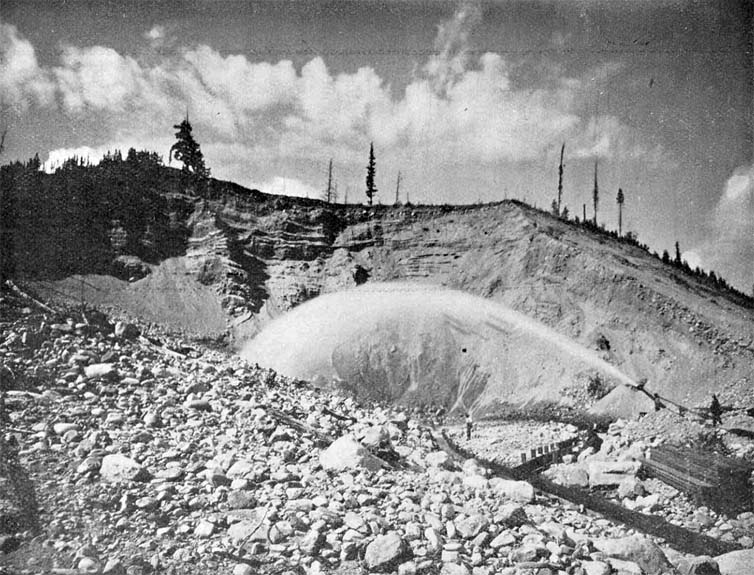
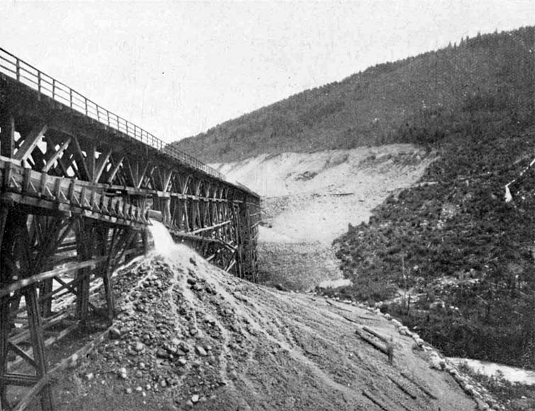
A much more expeditious and satisfactory method, and at the same time one which costs but about one-half of the dumping method, has been employed in two or three cases where abundant water-power was at hand, and also immense banks of gravel or morainic material. Reversing the methods followed by the gold washers of California, water was brought down from the streams above under great pressure, and with it the gravel and boulders were washed into large sluices, which carried them to the points where the filling was to be done. Here the water was allowed to drain away, leaving the gravel thoroughly settled in the new position. The filling was confined within the proper limits by means of logs laid in rows one above the other, and thus the embankment rose, tier above tier, the slope being kept well within the angle of repose, and the logs soon sprouting and forming a network of roots, firmly binding the mass together.
Mountain Creek is the point at which a large amount of filling has been done on this plan in a most successful and economic way. Water is obtained from the creek some two miles above, and is led down in a flume, two feet high and four feet broad, to the flume-box, which is 206 feet above the railway track. From this point an iron pipe 14 inches in diameter, of 3/16 inch thick metal, leads the water to the monitor, which is provided with nozzles ranging from 3 inches to 6 inches in diameter. The small-sized nozzles are use for breaking up the mass of gravel, while the larger ones furnish an increased volume of water to flush the sluices. Boulders 18 inches in diameter are readily moved without assistance, but two men with hooks are constantly on the lookout to clear any obstructions.
The sluice has a grade of about one in ten, conveys the material beneath the railroad track and deposits it in a great pile at the center of the area being filled. (Fig. 10. Page 22.) From this point it is gradually washed down until stopped by the row of logs at the edge, which however, allow the water to flow off freely. The sides are made to slope at an angle of 37 degrees 40 minutes, which is well within the angle of repose, but, in addition to this, the sprouting of the logs at the edge of the filling has formed a strong network of roots, binding the whole mass firmly together. (Figs. 8 and 9. Page 18 and 20.)
The cost of this filling is about one-half that of the ordinary way, but it is here carried on under great disadvantages. Not only must the work be entirely suspended between October and June, but the sluices and fixtures must be taken up in order to prevent wreckage by the avalanches, and so each spring the work must practically be constructed again. Nine men in all are required to conduct the filling, one at the monitor, two to keep the sluices clear, and six to prepare and lay the logs at the edge of the filling and to level off the material as it falls.
The total filling at this point will aggregate 300,000 cubic yards, of which 225,000 were put in place between June, 1897, and June 1899, leaving but 75,000 yet to be filled. A light steel trestle will complete the work connecting the two fillings, thus effecting a permanent solution of a very difficult problem. This method of hydraulic filling was first employed in the mountain division of the Canadian Pacific Railway under the direction of Mr. Edmond J. Duchesnay, C.E., Superintendent. It is a pity that this method can not be employed to advantage in many other localities where great fillings are necessary.
The highest point reached by the railway in the Selkirk range is at Selkirk Summit, 4,303 feet above tide. From this point the railway steadily descends, following the Illecillewaet River. The first routes surveyed lay on the slopes of Mt. Cheops, to the right, but these necessitating a steeper grade than the Government would allow, a change was made to the left side, and the length was increased by a great sweep up the valley of the Illecillewaet to within a mile and a half of the Great Glacier of the Selkirks. Then, following the slopes of Mt. Abbott, and executing a double loop like a letter S, the level of the stream was reached, which was followed as far as its junction with the Columbia River at Revelstoke.
This is a divisional point on the railway, and the crews and engines are changed. The pass over the Gold range is not high, and offers very little of special interest, while in crossing the Coast range the railway follows the canyons of the Fraser and Thompson Rivers, thus avoiding a summit. A few sheds are necessary on the western slope of the Gold range, of similar construction to those used in the Selkirks (see Fig. 2. Page 6.), but the snowfall being lighter, the same difficulties do not have to be encountered Some very heavy tunneling and cutting were required in the valleys of the Thompson and Fraser Rivers, a good part of which was constructed by the Government in the early days of the development of the country.
 The Onderdonk contracts along the Fraser and Thompson Rivers.
Thus the Rocky Mountain system is crossed after passing three summits, which, if their altitude is not great, still in location and construction required the greatest patience and skill on the part of the engineers intrusted with the task.
William S. Vaux - Proceedings of the Engineers' Club of Philadelphia, Vol. 17, No. 2, May 1900 - B.J. Lowther and M. Laing 1968, "A bibliography of British Columbia: Laying the foundations 1849-1899", University of Victoria, Page 161 - University of British Columbia Library Spam16557.
