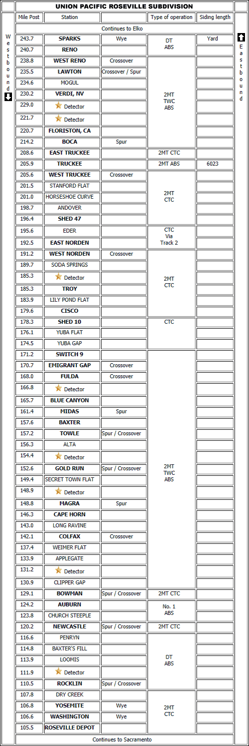


OVERLAND ROUTE
In 1846 the population of the United States of America was growing and on the move. While most people lived on the eastern side of the country there was a great emigration to the West seeking new land and opportunity.
For convenience and protection people setting out for the West gathered in groups to travel the long and difficult trails in wagon trains pulled by oxen.
One such party bound for California, consisting of three families and hired hands totaling 33 in number, left Illinois in April heading towards Stephens Pass in the Sierra Nevada mountains. Because of their choice of routes they were delayed reaching the pass arriving there at the end of October, just in time to find it blocked by deep snow from two unusually early and severe snowstorms.
Winter weather in the Sierra Nevada's can be brutal. At 400-450 inches per year, this is one of the snowiest places in America. Winds in the pass can also become extreme and 100 mph or greater wind gusts are common during winter storms. Temperatures in the area drop below zero several times each winter.
Barred from continuing, and low on supplies, some families camped by Truckee Lake while others stayed a short distance away at Alder Creek. Without food they slaughtered their oxen for meat. By mid-December it was apparent they would not survive the winter so fifteen of them set off westerly on snowshoes seeking help. Caught in a blizzard four of the party died while the survivors resorted to cannibalism to enable them to continue their journey. Three more died enroute and were also cannibalized by those remaining who finally reached safety on the western slopes in the middle of January, 1847.
Californians quickly assembled and rushed eastward to save those who remained camped in the pass. One Daniel Rhoads was a member of a rescue party who kept a diary of his experience, to wit:
"At sunset of the 16th day we crossed the Truckee Lake on the ice and came to the spot where we had been told we should find the emigrants. We looked all around but no living thing except ourselves was in sight and we thought that all must have perished. We raised a loud halloo and then we saw a woman emerge from a hole in the snow. As we approached her several others made their appearance in like manner, coming out of the snow. They were gaunt with famine and I never can forget the horrible, ghastly, sight they presented. The first woman spoke in a hollow voice very much agitated and said "Are you men from California or do you come from heaven?"
They had been without food except a few work oxen since the first fall of snow, about 3 weeks. They had gathered up the bones of the slaughtered cattle and boiled them to extract the grease and had roasted some of the hides which formed the roofs of their cabins.
When these emigrants had first been stopped by snow they had built small cabins using the skins of the slaughtered oxen for roofs. Storms nearly continuous had caused the snow to fall to the depth of 18 feet so that the tops of their cabins were far beneath the surface. When we arrived they were eating portions of the hides forming their roofs, which, hides being under the snow, were in a putrid condition. The bodies of those who had perished were lying on top of the snow covered with quilts. When a person died an inclined plane was dug to the floor of the cabin and the body slid up to the surface, the inmates being too weak to lift the corpse out."
It was apparent that after a time, here too at Truckee Lake, cannibalism had been required to sustain these last emigrants also.
If you haven't recognized this moment in history by now, let me help. The head of this party of emigrants was named George Donner. As a result of the terrible events that took place here in 1846-1847 Truckee Lake has since been re-named Donner Lake and Stephens Pass became Donner Pass, names we still associate today with those horrible events.
Wagon trains, as used by the Donner Party, were now obsolete.
It might be argued the Central Pacific had the most difficult part of the route as they had to cross the Sierra Nevada Mountains with numerous bridges and tunnels. Mainly Chinese labourers took nearly 3 years to construct four tunnels, several miles of snowsheds, and the two Chinese Walls necessary to breach Donner Summit, the most difficult engineering and construction challenge of the original Sacramento to Ogden route. In total, the Central Pacific had eleven tunnels, numbers 3 through 13, under construction in the Sierras from 1865 to 1868. Seven tunnels were located in a 2 mile stretch on the east side of Donner Summit. The summit tunnel, Number 6, at 1,660 feet long and nearly 7,000 feet elevation was started in late 1865 before end-of-track reached that point. To keep the line open during winter 37 miles of timber snow sheds were required between Blue Canyon and Truckee. Bucker snowplows pushed by the locomotives, as well as manual shovelling, were used on the open stretches.

As time progressed traffic over the route continued to increase. By the turn of the century transcontinental traffic, including helper locomotives, was so heavy that the telephone block and train order system was unable to cope. Between 1905 and 1906 a unique staff system
 was installed to relieve the delays.
With a train's pulling power supplied by wood burning steam locomotives at that time you can readily imagine the effect the interior of smoke filled and sooty tunnels had on the locomotive crew. As time passed and the Southern Pacific Railroad took over the Central Pacific, locomotives became larger and more powerful burning coal or oil, so the Donner Pass snowshed and tunnel ventilation problem became acute, carbon monoxide being deadly. One solution was to fit the crew with a smoke mask. Somewhat impracticable this led the railroad to create the now famous Southern Pacific Cab Forward steam locomotive.
The problem didn't disappear with the diesel era as the numerous tunnels and snowsheds caused overheating of the diesel engines. Hence, the Tunnel Motor.
The Southern Pacific was acquired by the Union Pacific one hundred and eleven years later, in 1996. This take-over included the tracks on Donner Pass which they still use today, excluding some now abandoned original tunnels and snowsheds.
While this merger game was played out the one thing that has remained constant throughout has been the winter weather at Donner Pass. And that means Snow!
Moisture laden Pacific Ocean air blowing west reaches Donner Pass, at an elevation over 7,000 feet in the high Sierras, creating tremendous amounts of snow. During the winter of 1951-1952, 65 feet of snow fell at Donner Summit. The City of San Francisco, Southern Pacific's luxury streamliner, with 226 passengers and crew members onboard was trapped in a snow drift for 4 days. Although all 226 people survived, two rescuers died in their efforts to save those onboard.
Today, records of the railroad's efforts to combat the huge snowfalls are still apparent in the number of abandoned and still operational snowsheds along the line. Remnants of the Central Pacific's Chinese labourers work constructing a route through Donner Pass are visible above Donner Lake, principally the Chinese Wall on this now abandoned section of the route. This tortuous route clinging to the mountainside has been replaced by a modern tunnel. Concrete snowsheds protect the track in many places along Union Pacific's current trackage over the High Sierras but trains are still delayed due to winter snowfalls.
These historic photographs below, from Donner Pass, Truckee, and the Sierra Nevada's, found on the internet are interesting. Unfortunately sometimes they pose more questions than answers. Data pertaining to a photograph, the photographer's name, or a date, or even an explanation of the subject matter is just not there or incorrect. However, they are well worth while examining.
 |  |  |
 |  |  |
 |  |  |
 |  |  |
 |  |  |
Now the area photographed for this story was NOT surveyed during winter, but in mid-May 2007. The temperature varied from shirt sleeve hot (80F) during the day to shivering cold (32F) at night. Snow still remained on the shady side of Donner Summit and was visible on the higher surrounding mountain peaks.
The Truckee River flows north from Lake Tahoe to Truckee, California, where it is joined by Donner Creek flowing east from the lake. The Truckee then continues northeast towards Reno, Nevada. Reno is the home of the ReTRAC Project, an interesting solution to the problem of two Union Pacific main lines cutting through the center of a city.
Reno was my base for four days with daily trips back to Donner or Yuba Passes to catch the trains moving along Union Pacific's route over the Sierra Nevada summit. There were some long waits. I broke my previous record at one particular site by waiting over 5 hours for a train to pass by. My radio scanner had died so there was no possibility of listening to radio traffic. It was back to the good old fashioned hurry-up-and-wait method of railfanning that pays off... eventually. On one particular day I was surprised to find two Tunnel Motors in consist lead by a clean, modern, General Electric unit (AC45CCTE).
Now don't get the idea there wasn't any pre-planning for this trip. On the contrary, countless hours were spent examining Google satellite images and switching to their hybrid map for orientation. Several possible sites that might produce good scenery shots with train action were chosen and entered into my vehicle navigation software prior to departure for Truckee. Upon arrival I discovered that to reach most sites a 4x4 vehicle is required, and one photo site even meant fording a foot deep stream. In the time spent in the area not all sites were explored. There were several others that deserve to be reconnoitered. In some cases there is no vehicle access due to gates and the only option is to walk, usually up a steep hill, in the heat, carrying your gear. Who was that great railfan sage who said "If you can't drive to it, the photo ain't worth takin'"?
Would I go back? Certainly. The area doesn't have the easy access found at Tehachapi, California, but there are some interesting photo locations well worth a visit to this area. Truck on down to Truckee but be prepared to wait for the California Zephyr!
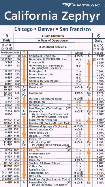
The California Zephyr timetable is out of date but it gives you an idea of the route.